LBR Report August 8-10

Lynnhaven Boat Ramp
Channel from Lynnhaven Boat Ramp to Lynnhaven Inlet

During the high season in Virginia Beach, Parks and Recreation staff share weekly updates regarding weekend activity at the Lynnhaven Boat Ramp (LBR):

“This past weekend August 8-10 was comparatively slower overall to our higher attended weekends this summer. Again, there were small craft advisories for most of the weekend and it very windy each of the days. We had a total of 320 launches over the 3 days:

Friday, August 8 –       34 total launches, car parking did not fill up there was available parking throughout the day. The overflow lot was not used. We did not have to close using the barricades at any time.

Saturday, August 9 –  137 total launches, car parking filled around 10:55am and was busy the remainder of the day.  The overflow was not used.  Barricade operations were not needed.

Sunday, August 10 –   149 total launches, car parking was full from 10:30am-6:30pm. The overflow was used for 15 vehicles. Barricade operations were not needed.

Incidents to report:

  • Captain Gordon reported that on Thursday, August 7 the midnight shift officers held their muster meeting at the boat ramp.
  • Staff reported that they spoke to several of the party barge captains to explain and reinforce getting their passengers loaded and unloaded quicker and not to tie up the docks while waiting. All were compliant. 
  • On Sunday afternoon we had a boat breakdown on Ramp #4 which slowed launching and recovery operations down for a short period.
  • Review of video data from Friday until Monday morning showed limited car traffic after hours. Police Real Time Crime Center was seen monitoring the cameras during the overnight. Security is doing a great job of keeping cars out of the trailer lot and checking the front lots as requested.
  • Staff have reported one of the Dominion Power lights in the parking lot is out. We have submitted a work order to have it looked at.

Additional information:

  • The purchase orders for digital real-time Full/Open signs for the boat ramp have been received and the signs are on order. Delivery and install TBA.

LBR Activity Report: July 18-20

During the high season in Virginia Beach, Parks and Recreation staff share weekly updates regarding weekend activity at the Lynnhaven Boat Ramp (LBR):

“Overall, the weekend was a bit slower for launches due to the marine forecast and expected late afternoon thunderstorms, but the car parking continues to be very heavy throughout the day. We had a total of 468 launches over the 3 days. Below is a breakdown by day:

Friday, July 18: 85 total launches, car parking did not fill up. The overflow lot was used for 4 trailers. We did not have to close using the barricades at any time.

Saturday, July 19: 208 total launches, car parking was full from 9:15 am until around 8:00pm. The overflow was used for 56 vehicles with trailers. Barricade operations was not needed. Heavy car traffic all day through 9pm.

Sunday, July 20: 175 total launches, car parking was full from 11:00am – 8:15pm. The overflow was used for 25 vehicles. Barricade operations was not needed.

Incidents to report:

On Friday night around 8:45pm, a person on a jet ski was reported to have been traveling at a high speed on crab creek and creating a large wake. When the rider came to the ramp, a resident whose home backs up to crab creek, approached the rider about the wake she created and potential damage to his boat that was moored on his dock. Staff and security intervened and it was de-escalated and the resident left the boat ramp.

Review of video data from Friday until Monday morning showed heavy car traffic after hours until after midnight Friday and Saturday night but no visible loitering in the parking lots. Police were onsite Saturday night/Sunday morning from approximately 11:30pm-10:50pm walking around and keeping cars out of trailer parking. Police also came through the lot Sunday morning around 12:50am.

Garda Security is working well. We have been working with the contractor and Emergency Management to fine tune the standing orders. Approximately 6 residents were out last Thursday, first night of security, to introduce themselves.”

LBR Activity Report: June 27-29

We receive reports from the Department of Parks and Recreation about the activity levels and events at the Lynnhaven Boat Ramp. We provide this information so that the community is aware of the numbers and what the Parks and Rec employees are seeing.

LYNNHAVEN BOAT RAMP | WEEKEND REPORTS

Overview: During the high season in Virginia Beach, Parks and Recreation staff share weekly updates regarding weekend activity at the Lynnhaven Boat Ramp (LBR). These updates are captured below and are regularly distributed to the Bayside Advisory Committee (BAC) Chair and to the Ocean Park Civic League (OPCL) President, among others, for further dissemination.

JUNE 27-29, 2025

Another hot weekend in the books. We had a total of 532 launches over 3 days. Below is a breakdown by day:

  • Friday, June 27: 127 total launches, car parking was filled from 630am-730am due to some type of run event. The remainder of the day was ordinary parking use. 
  • Saturday, June 28: 221 total launches, car parking was full from 9:25 am until around 9:00pm. The overflow was used for 61 vehicles with trailers.  
  • Sunday, June 29: 180 total launches, car parking was full from 10:20am-415pm. The overflow was used for 41 vehicles with trailers. Heavy rain around 6pm. 

This weekend was very busy, especially on Saturday. Staff were able to manage traffic and parking of trailers so that barricade operations were not needed.

Incidents to report:

  • Friday from 630am-730am: a large group of runners came to the facility to park for a meet up run. There were many cars parked in the boat ramp parking. Staff were not aware in advance and there were no scheduled or permitted activities for this day for this facility. Staff did receive a call from Mrs. Dawe asking about what was happening. Staff told her that it appeared a running group had a meet up run. 
  • Saturday at about 12:30pm: the fire department showed up to facility as response to a call of a disabled jet ski out in the bay. 

Review of video data from Friday until Monday morning showed a lot of cars after hours until after midnight each night but no apparent loitering in the parking lots.  

Parking Enforcement: 38 citations written (for a total of 309 citations written since April 1)

Sunday? Why are the 🎇Fireworks 🎆 on July 6th?

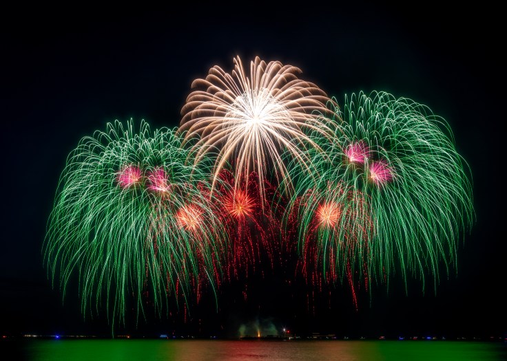
Putting on the fireworks show over the bay that we enjoy every year is more complicated than many folks realize. This year the date of Sunday, July 6th was chosen carefully with many factors of cost and logistics in mind. Fireworks czar Jill Doczi explains:

Let’s start with the barge:

We can’t just use any barge. It has to be a certain-sized, oceangoing barge with a certain kind of edge around it and certain features. There are major, multi-year projects on the HRBT and the CBBT utilizing those types of barges, and the cost to get those to unload all their equipment, suspend their scheduled work and move from their locations for two days would be unthinkable. We (and the oceanfront) almost didn’t have a show about three years ago because there was no barge to be found in along the East Coast. We, the city, the fireworks company, etc. looked hard for months before we found one, which we shared. When there is a shortage of barges, you work with what you have. What we have is a barge being used already on July 4 that we are lucky to be using. We explored the option of doing it on Saturday, but the cost was way too high.

Contraints on the crew for the fireworks:

A crew, each of which has to be highly vetted far ahead of time by multiple security agencies, is dedicated to our show. It IS essentially a giant bomb that floats past vital shipyards, Little Creek Amphib Base and over major tunnel-bridges like HRBT and CBBT, so the people involved can’t just be found on the street to work for a day gig. They must have multiple permits at the federal and state level as well as longshoreman insurance.

It takes over a day to load in Chesapeake for that first show. Then it takes half a day to get to that shooting location. They shoot on Friday night at the Oceanfront, and it takes them the same amount of time to get back to Chesapeake, where the crew gets to rest because they’ve already been working nonstop with dangerous cargo since early the day before. Then they go back to work to prep and load our show, which will take a day to do.

If we wanted to shoot on Saturday night, the crew would have to be relieved by a second crew after being up so long, and our show would absorb the cost of the second crew, their permit fees, their travel, hotel, per diem, lodging, insurance, etc. If you’ve ever worked in maritime, insurance for Jones Act and workers comp is crazy. That second crew would then sail over to us (taking half a day), shoot our show and return in the middle of the night to Chesapeake to disassemble, load their things and go home.

BOTTOM LINE: We couldn’t absorb the 💰cost of a second crew, nor could we absorb the cost of a separate barge on our own (if there was one even available), so it became: Give the crew the required and necessary break and shoot on Sunday night or don’t have a show. The neighborhoods chose to have a show.

Keep in mind, this is only the logistics of the barge and crew. We also need to have an available tug and staff, the city services must be available on a busy holiday. VB fire marshal must be on site the entire time in Chesapeake while the barge and explosives are there, then on site here in our beach while the barge is here. As you can imagine, the fire marshal’s department is busy July 4, so they’re stretched thin. We also have to have a plan in place with a city special events person, beach police,⚓️ maritime police and Coast Guard to be on site for our show. They are stretched thin on July 4 as well.

Jill continues: “I’m anticipating the next question.”

Why can’t we just have it on the beach and get rid of about half those issues?

  1. We aren’t allowed to close off a large area of the public beach for the entire holiday weekend to prepare, load and have a show on the sand. Can you imagine how upset people would be if we had to block off our beach across multiple accesses? But that doesn’t matter anyway because of the next answer.
  2. After the Ocracoke fireworks explosion in July 2009 that killed and injured multiple people, safety rules tightened up everywhere. You can only load shows that are far enough away from people and structures to keep them from harm. So we can’t trot giant 8-foot-diameter explosives down the beach paths all day with houses 16 feet on either side and people using the already full beach on a holiday. We also couldn’t place explosives with the capability of flying 800 feet sideways within 250 feet of houses and people.
  3. Side note: This is also why it has to load in at an industrial dock in Chesapeake. Imagine the fire power of an entire truck full of hundreds of shells and what that could do to a block of houses on Jefferson or Sandy Bay, or even the boat ramp. It would never be permitted by the fire marshal.
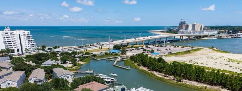
  4. There are SOME shows that can shoot from land, but, they must have a safety perimeter that meets the requirements. For instance, a 2-inch shell can fly roughly 200 feet in any direction, including sideways, so if you want to load a show with 2-inch shells or smaller, there have to be no buildings or people within 200 feet of the loading area or the show. That also means the fireworks are lower and harder to see by a wide crowd because they explode at 200 feet. A 3–inch shell needs 300 feet of load in and crowd-viewing perimeter, etc. The little ones that look like they’re exploding right above the barge deck are 2-inch shells. Our show uses up to 8-inch shells, so the whole beach gets a good view. The barge is so far out to get the necessary 800 to 1,000 feet of safety perimeter. That’s why Coast Guard and marine police are required to secure that perimeter. If an 8-inch shell got lose and shot sideways, it couldn’t hit anyone on the beach.

There is no way we could meet safety requirements to load a show in and shoot on our beach unless we’re talking some guys with bottle rockets, which would be a sad, sad show.

It’s a LOT of information. Trust me — I know. 😉 But, hopefully it answered multiple questions for multiple people. Short answer: It boils down to safety and cost.

THANK YOU JILL AND ALL THE VOLUNTEERS AND ALL THE WONDERFUL PEOPLE WHO CONTRIBUTE TO MAKE IT HAPPEN!

Your donations are GREATLY APPRECIATED!!

LBR Data for Recent Weekends

This data comes from Michael Parkman, Parks and Rec Supervisor.

Friday, June 13 – 91 total launches, car parking did not fill. The overflow was used for 2 vehicles with trailers.

Saturday, June 14– 135 total launches, car parking was full from 10:45 am until around 5:45pm. The overflow was used for 3 vehicles with trailers.

Sunday, June 15– 75 total launches, car parking was full from 1:30pm-3:00pm. The overflow was used for 3 vehicles with trailers.

  • At no point during this weekend did we have to close access to the facility.
  • Review of video data from Friday until Monday morning showed about 10-15 cars in the parking lot closest to the bridge until around 11pm on Friday night. Saturday night was a bit slower overall after hours. Police real time crime took control of cameras around 2-3am Saturday morning. Appeared to be watching a small group of individuals milling around their cars.

Friday, May 30 – 93 total launches, car parking did not fill.

Saturday, May 31 – 189 total launches, car parking was full from 11 am until around 5:45pm. The overflow was used for about 48 vehicles with trailers.

Sunday, June 1– 59 total launches, car parking did not fill.

  • At no point during this weekend did we have to close access to the facility.
  • Saturday was a very busy day not only with launches but also lots of beachgoers. Staff did receive a complaint from a couple citizens on the beach about loud “inappropriate” music coming from a specific group on the other side of the bridge from the boat ramp property. Staff investigated but found the group to be very large and did not feel safe approaching them. Staff did advise the citizens that complained to also call police non-emergency if it continued to be an issue. 
  • Review of video data from Friday until Monday morning showed about 20-25 cars in the parking lot closest to the bridge between 9:30pm and 12am Friday and Saturday nights. All these cars were parked legally and there were very few people milling around the lot during this time. My assumption is that people were on the beach.

Join us 💥tonight Thursday, June 5th at OPVRS🚑 or also on ZOOM! ( NOT at Brock.. see you at the Rescue Squad!🚑)

The June 5th Ocean Park Civic League General Meeting will be held at the Ocean Park Volunteer Rescue Squad on Shore Drive at 7:00 pm. The agenda includes updates from Councilman Joash Schulman and on other ongoing issues and civic league activities.

Zoom link for Thursday’s meeting.

Resolution to Expand the Pleasure House Point Natural Area

Whereas the Pleasure House Point area provides a durable and resilient natural separation between Crab Creek and the developed areas of Ocean Park. Virginia Beach is at risk from more frequent recurring flooding due to the effects of sea level rise. While the City is evaluating flood mitigating infrastructure projects that could actively reduce the risk of flooding in Ocean Park, Ocean Park’s current flood risk can be best maintained by continuing to preserve the Pleasure House Point Natural Area. Pleasure House Point Natural Area is a vital environmental asset and community resource for the city of Virginia Beach. Environmentally, its expansive tidal wetlands contribute to the biodiversity and health of the ecosystem by providing habitat for numerous birds, fish, and other wildlife, including species of conservation concern. These wetlands naturally filter pollutants, improving water quality in the Lynnhaven River and the Chesapeake Bay watersheds. It offers natural flood protection by absorbing stormwater and tidal surges, which is crucial in safeguarding nearby neighborhoods and infrastructure from stormwater flooding and sea level rise, thereby protecting the community. For visitors and residents, Pleasure House Point offers substantial open space and canopy trees, allowing for a variety of recreational opportunities, including nature observation, fishing, and birdwatching. Privately held properties adjacent to Pleasure House Point Natural Area are essential for protecting its ecological value and public benefits.

Now, therefore, be it resolved that the Ocean Park Civic League encourages city, state, and federal agencies to prioritize the voluntary conservation of properties adjacent to Pleasure House Point Natural Area. Supports efforts by conservation groups and philanthropists to acquire land or secure conservation easements through incentives and partnerships. Invites property owners to consider voluntary conservation agreements, such as easements or restoration projects, while fully respecting their development rights. Recommends using tax incentives and grant programs to make conservation attractive and feasible. 

The Ocean Park Civic League Board of Directors was approached in late November 2024 regarding the Virginia Beach City Council’s decision to pursue the Wetlands Mitigation Project at Pleasure House Point. Understanding the considerable impact this project would have on our community, we quickly reached out to our partners at Chesapeake Bay Foundation (CBF), Lynnhaven River Now (LRNow), Friends of Live Oaks (FOLO), and others to gauge their expertise on strategies moving forward. We also took the time to discuss the project with, and learn details from, our elected officials, local experts, and our residents.

Those discussions confirmed that local environmental experts (e.g. CBF, LRNow, etc) support of the project. Their statements are available on our website (www.opcl.org). We also learned the City intended to quickly move forward with this effort despite the significant impact to the maritime forest to advance flood mitigation efforts across the Lynnhaven River. Our understanding is that wetlands restoration was the intent for this property since 2012. Over the years, the delays in moving forward with the wetland restoration project resulted in profound tree growth in the area as nature took its course, creating the space we all know today.

While this project will have considerable impacts to our neighborhood, the long term outcomes will result in an accessible, preserved natural area that encourages a healthier Lynnhaven River. We are saddened at the loss of the maritime forest and habitat in these 12 acres and appreciate the help of our many neighbors who have volunteered their time to preserve the space, from moving saplings to undergoing trainings to help wildlife in the area. We also appreciate the efforts of our neighbors who have worked with us to hold our representatives accountable.


Collectively, our passion for our neighborhood is unparalleled and speaks volumes to how special we know this area of Virginia Beach to be. We appreciate everyone’s dedication to this effort and look forward to our continued partnerships on behalf of our neighborhood.


Respectfully,
Ocean Park Civic League Board of Directors

Updates on PHP Wetlands Project

Additional information from Councilman Joash Schulman and the Dept of Public Works in response to questions from the community about the Wetlands Project at PHP.

Comment 1: Credits exist from three banks servicing the Lynnhaven Watershed (02080108), why doesn’t the city purchase them from these banks instead of building the PHP Bank?

Answer 1: We are aware of these banks but only one has tidal wetland credits, and those tidal wetland credits have only become available recently. The existing non-tidal and tidal banks are as follows:

  • New Mill Creek Tidal Mitigation Bank – has 5.27 credits of various types relating to tidal wetlands
  • Chesapeake Bay Wetland Mitigation Bank – has no (0.00 tidal wetland credits for sale), and has 3.9 credits of non-tidal wetland credits.
  • Virginia Aquatic Resources Trust Fund (VARTF) – has no (0.00 tidal wetland credits for sale). They have various sites, but all are for non-tidal wetland credits. 

Comment 2: The City has the opportunity to purchase credits right now, from banks servicing the Lynnhaven watershed (02080108) per the USACE. The City has purchased credits from New Mill last year. 

Answer 2: As noted above there is only one bank with tidal wetland credits and that bank has 5.27 tidal wetland credits to serve the Elizabeth River watershed, lower James River watershed and the Elizabeth River Watersheds. (The credits are needed in the Lynnhaven Watershed).The City has not only the needs of the Windsor Woods Pump Station and the London Bridge Creek flood gates and pump station projects (approximately 2.7 credits) to mitigate in the future, but other City projects that will have a need for tidal wetland credits as well. Even if the City could somehow purchase all the credits from that bank, it may not satisfy all the City’s future need for credits. Additionally, purchasing credits well in advance of the formal permit application process is counter to the federal regulations. 

Specifically, credits are not to be purchased before the proper permit applications are submitted, reviewed by the necessary federal and state agencies and those same agencies verify that impacts to tidal wetlands are minimized to the maximum extent practicable, and only then can discussions about credits be discussed in detail. The only exception is unless the applicant owns its own mitigation facility. By the City owning its own mitigation bank, it is sure that those credits are 1) available when needed in the future and 2) will be accepted by the agencies when the time comes that they are needed. Otherwise, the City is now not even at the point to discuss use of the New Mill Creek Tidal Mitigation Bank with the Federal and State permitting agencies.

While the New Mill Creek Tidal Mitigation Bank has credits available, that does not mean that the City can automatically rely on their availability in the future when needed. Additionally, there is a second set of decisions that must be made by federal and state regulators, and which can only be made at the time of permitting; namely, whether a bank with credits to sell is the appropriate mitigation for a project, and that project’s watershed. The problem the City of Virginia Beach has is that the City has a very large project (Windsor Woods, Princess Anne Plaze & The Lakes Flood Protection Project (Megabundle Project), with large projected impacts to tidal wetlands within the Lynnhaven River Watershed. That permit application has not been submitted yet, and will be decided on by federal and state agencies about 1.5+/- years from now. The City cannot risk finding out 1.5+/- years from now that the agencies disallow use of the New Mill Bank , which could occur because it is not in the Lynnhaven River basin. The risk is that while the credits are coming from the Elizabeth River watershed, there would still be a large net loss of wetlands in the Lynnhaven River Basin. If the agencies were to decide that is not appropriate, they would notify the City that the City needs to proceed with constructing the PHP Bank as it is located in the Lynnhaven River watershed and thus would offset the impacts occurring in the Lynnhaven River Watershed.

The agencies know the City owns the PHP Bank, and has secured all the City, Federal and State agency signatures needed on the Banking Agreement. If the City were to wait 1.5 years and learn then they needed the PHP Bank, it would cause enormous delays to the schedule of the Megabundle Project, risk another flood event to those communities, and cause substantial monetary impacts to the Contractor and the City. It was too great a risk to the City and the flood protection project and is why City Council voted unanimously on January 7 to fully fund the PHP Bank. 

Additionally, the agencies do not want cities or any persons to acquire wetland credits in advance of the formal permit application process for the reasons noted above. Those regulatory agencies are the arbiters of when purchasing or using mitigation credits is appropriate, and that cannot be decided until approximately 1.5+/- years from now for the Megabundle. It is simply too much of a risk to wait that long to find out the answer when the City has a fully approved mitigation banking agreement in place for the Pleasure House Point Bank. This same situation will repeat itself in the future for each subsequent City project impacting tidal wetlands in the Lynnhaven watershed.

Lastly, the City has a public interest in maintaining tidal wetland acreage and water quality in each of its watersheds. The Lynnhaven Watershed is one of the most highly developed watersheds in the City and has experienced significant historical tidal wetland loss. One of those losses was the filling of tidal wetlands at the City’s Pleasure House Point Natural Area during the 1970s+/- with dredged material from the Lynnhaven Inlet. The City does not want to have additional net losses of tidal wetlands occur in the Lynnhaven Watershed, let alone have a net loss of tidal wetlands in the Lynnhaven Watershed due to a City project(s). This is in part why the City initiated the Pleasure House Point Tidal Wetland Mitigation Bank in 2012+/-.

Pleasure House Point Wetland Mitigation Project

More information from the City of Virginia Beach about the PHP Wetlands Mitigation Project:

Video of the December 19 Wetlands Project Presentation and Question/ Answer at the Bayfront Advisory Commission Meeting. https://www.youtube.com/watch?v=x5VR6P7-2do

The Virginia Beach City Council heard a briefing on the Pleasure House Point Wetland Mitigation Bank project: City Council Presentation video November 26, 2024.

From Councilman Schulman:

“We’ve heard from many residents who have questions and concerns about the Pleasure House Point Wetlands Mitigation Bank project. Here are some things to know:

Community input is critical to the success of a project like this. Neighbors, area civic leagues, and local environmental organizations like Lynnhaven River Now, Chesapeake Bay Foundation, Friends of Live Oaks, Wetlands Watch, and our VBCPS Environmental Studies Program at the Brock (both staff and students) have all been alerted and are being kept informed and actively participating in the conversation around this project. I hope you will join us for the BAC meeting. If you can’t make it, please feel free to send me any thoughts or questions to jschulman@vbgov.com.

The project involves restoring 8 acres of the 12.3 acre project area to their previous natural state as wetlands. Prior to the 1970’s the project area existed in a natural condition as a partially wooded inlet with a broad expanse of wetlands. Between 1971 and 1972, the U.S. Army Corps of Engineers (as part of dredging the Lynnhaven Inlet) placed over one million cubic yards of dredge material over these wetlands.

The wetlands mitigation bank project was originally conceived in 2014 and went through 90% design and permitting in 2018 but was ultimately not completed due to a lack of funding and there was no compelling public need to justify the cost. These designs and construction plans were part of a larger comprehensive plan that was the result of much public participation.

There is now a compelling public need for the mitigation. This wetlands mitigation bank project will support the City’s critically important Flood Protection Program. The purpose of a Wetlands Mitigation Bank is to provide a way to offset wetlands losses that occur elsewhere in the same watershed, or “Hydraulic Unit Code Zone” (HUC Zone). The city, as part of its Flood Protection Program projects (like the Bow Creek Stormwater Park, Thalia Creek Tide Gate, Southern Rivers Watershed projects, and other road projects, in general) can cause impacts to wetlands. Under Federal and State law those impacts must be compensated for, to ensure no net loss of wetlands. There are no wetlands mitigation banks in our HUC Zone, and because of the public need associated with the multigenerational investments we are making in our Flood Protection Program, the need for this wetlands mitigation bank has become acute.

It’s important to note that the wetlands mitigation bank credits made available by this project are restricted for use with city/public projects only.Credits will NOT be available for private property owners or developers in connection with projects that impact wetlands on private property.

The process of converting highlands to lowlands, in this case, will involve a conversion from volunteer trees to valuable wetlands. I’ve asked that our City Arborist take an inventory of the trees in the area so we have a sense for the scope and so we can look for ways to minimize impact. Importantly, the wooded areas to the West of the project site are protected by a conservation easement.

The Pleasure House Point Natural Area (all 118 acres) will continue to be managed as a Natural Area Preserve by the City of Virginia Beach Department of Parks and Recreation. As part of the project, the city will be planting 600 trees. 336 of those trees will be Live Oaks and 129 trees will be Water Oaks. While all trees have value, Live Oaks and Water Oaks are hardwood trees with significantly more species value than Pine (which is what is mostly on-site currently).

There have been questions as to whether this plan involves a kayak launch. The project scope ONLY includes the wetlands mitigation bank, not a kayak launch. The concept of a launch needs to be more thoroughly and thoughtfully vetted, being mindful of the potential associated negative impacts of having a facility of that type on this property.”

Blog at WordPress.com.

Up ↑